 Geology
Geology
|
SYNOPSIS OF HOMESTAKE MINE GEOLOGY Thomas J. Campbell
The historic Homestake Gold Mine is
located in the Lead Window in the northern Black Hills of South Dakota and
is hosted in Precambrian rocks that are approximately two billion years
old. Gold was the major commodity produced by the mine with silver
recovered as a byproduct. Base
metal content was negligible. The deposit was mined over a time span of
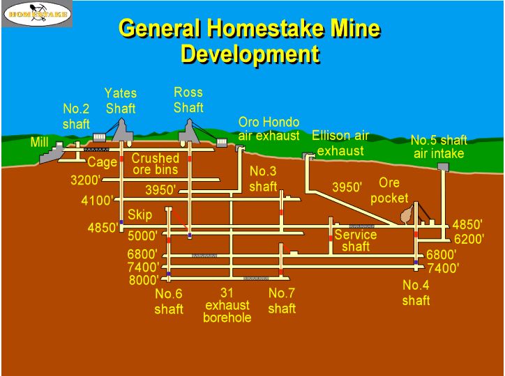
126 years with a large infrastructure that is comprised of two surface
shafts (Ross and Yates), three underground winzes (numbers 4, 6, and 7),
hundreds of kilometers of drifts (mine workings excavated parallel to
foliation/fabric) and cross-cuts (mine workings that transect
foliation/fabric), thousands of stopes (mined ore bodies), and numerous
surface structures. Most stopes have been filled with rough waste (from
development work) and/or sand fill (tailings) from processed ore. Workings
are developed in a block of the Early Proterozoic Earth’s crust that is
approximately 2.7 x 3 x 5 km with 6.5 km of plunge length. Homestake
rocks comprise a variety of metamorphic rock types subdivided into three
distinct units: Poorman, Homestake, and Ellison formations, listed from
oldest to youngest. The base of the Poorman Formation consists of
metamorphosed tholeiitic basalt with possible back-arc basin affinities
whereas the remaining Poorman lithologies are metasediments that include a
complex succession of rock types. These include metamorphosed equivalents
of dirty dolomite, banded carbonate-rich claystone and siltstone, marl,
iron formation, carbonaceous pyrrhotite-bearing siliceous exhalite, and
interbedded tuffs. Poorman metasediments are interpreted as chemical
precipitates dominated by Ca and Mg carbonates admixed with fine-grained
terrigenous detrital material that constitute hemipelagic basin fill
followed by input from seafloor volcanic exhalative activity and minor
volcanic ash. This metasedimentary sequence was followed by a transition
to Fe and Mg carbonate chemical precipitation and iron formation near the
top of the Poorman Formation and into the Homestake Formation.
Multiple horizons of carbonate facies iron formation interlayered
with marl are abundant throughout the Homestake Formation. Finally,
tectonism was rejuvenated in the area and deep marine fans encroached into
the basin that formed the superjacent the Ellison Formation which is
interpreted as a metaclastic sequence dominated by feldspathic litharenite
with abundant shale, siltstone, and tuffaceous units. Metamorphic
grade of these rocks ranges from middle greenschist in the western part of
the mine to middle amphibolite facies in the deep, eastern section of the
mine. The entire rock package was subjected to several periods of
deformation during the Precambrian resulting in complex fold patterns, and
significant, localized shear zones. Regional prograde metamorphism was
overprinted by a metamorphic event that is related to the emplacement of
the Crook Mountain Granite (very similar to the Harney Peak Granite found
in the central and southern Black Hills). This granite is located in the
subsurface northeast of the mine and is interpreted to be contemporaneous
with some of the younger, Precambrian age deformation and fluid events
found in the mine area. During the Tertiary period, rocks in the Lead
Window were subjected to a brittle phase of deformation accompanied by the
emplacement of alkalic igneous intrusions. This late, brittle phase of
deformation is responsible for the joint sets found in the Lead Window
along with local faults exhibiting minimal displacement. Aside from man
made accesses into the mine, it is the network of these later stage
brittle features that influence the influx of meteoric water into the mine
workings. Drifting, cross-cutting, and diamond drilling have locally
intersected these fracture systems or “watercourses”, as they are
called by the miners, and encountered medium to high temperature (45 to 85ºC)
water under low to high pressure. Ore
mineralization consists of pyrrhotite, arsenopyrite, +/- pyrite, and
native gold associated with chlorite group minerals, quartz, siderite,
ankerite, and biotite. This Precambrian mineralization is intimately
associated with a specific stage of quartz veining and ductile shear
zones. Individual ore bodies are relatively undeformed, pipe-like to
tabular bodies that vary from sparse to densely clustered, depending on a
variety factors that include shear intensity, quartz vein development,
rheologic contrasts, and host rock mineralogy. Ninety-five percent of the
gold mineralization is hosted in the Homestake Formation with the
remainder in the Poorman Formation and to a much lesser extent, the
Ellison Formation. In
terms of mine geography as it relates to the geology and fold structures,
the large-scale synforms and antiforms have smaller scale fold structures
associated with them termed “ledges”. If these ledges are synclines,
they are odd numbered from east to west (3, 5, 7, 9, 11, and so on) and if
they are anticlines, the structures are appropriately even numbered (6 and
10 ledges are the most significant). The exception to this is found in the
historic, easternmost ledges that are termed Caledonia and Main ledges;
Main Ledge was the most prolific ore system in the mine that technically
starts out as an anticline and down-plunge, the ore progressively rakes
across the structure and favors the synclinal part of the fold. Over 40
million ounces of gold were produced from all of the ledges that were
mined during the 126 year history of this world class gold deposit that is
the prototype for Precambrian iron formation-hosted gold deposits.
|
General location map of the Black Hills and Homestake ------------------ Geologic map of the Lead Window ------------------ Plan view of the ledges in Homestake ------------------ Generalized cross-section of a portion of the Homestake Mine ------------------ Characteristics of the Yates Unit Amphibolite (PDF) ------------------ ----------------------
|